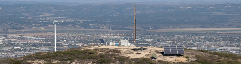
Technical Data
| Latitude | 34° 36' 12.9" N NAD83 |
| Longitude |
120° 29' 20.6" W NAD83 |
| Latitude |
34° 36' 13.00" N
NAD27 |
| Longitude |
120° 29' 17.00" W NAD27 |
| Site |
4 Miles SSW Of Lompoc CA 93436 |
| Elevation Above Mean Sea Level
(AMSL) |
470 meters |
| Overall Height Above Mean Sea
Level |
509.6 meters |
| Antenna Structure Overall Height
Above Ground (AGL) |
39.6 meters |
| Height Above Average Terrain
(HAAT) |
304 meters |
| Primary Power |
2.4kW Dual Axis Tracking Solar Panel array |
| Secondary Power |
Wind, 1kW HAWT (In Work) |
| Battery Storage |
400 Amp-Hour, 48VDC |
| Back-Up Power |
6kW LP Generator |
| Back-Up Fuel |
500 Gallon LP Tank |
| Commercial AC Power |
Build-To-Suit |
| Antenna Structure |
53' Pole, W/60' 2-3/8" Galv. Mast |
| Obstruction Lighting |
LED, Solid Burn, W/Photocell |
| Rack Space |
6' Rack, 4' Available,
Build-To-Suit |
| Other Features |
Internet Access, VOIP Phone
Line, 24 Hour Security & Web-Cams, Real-Time Telemetry &
Data-Logging, 1.8m Satellite Dish |
| Site Suitability |
Cellular Carriers, FM Broadcast
& Translators, Satellators, Microwave Repeaters, Wi-Max, Wind/Weather Data
Collection |
| Coverage |
Lompoc Valley, Mission Hills,
Vandenberg AFB, Santa Maria, Santa Ynez, Highway 1, North Coast |